
Spain’s irrigation sector has undergone significant transformation through investments in modern infrastructure, including pumping stations and pressurised distribution networks. However, infrastructure alone does not guarantee efficiency. A new challenge is emerging: ensuring water is applied in the right place, at the right time, and in the right quantity.
Traditionally, irrigation decisions have relied on experience and established practices. While effective to a degree, this approach can lead to inefficiencies, particularly in a context of increasing water scarcity, rising energy costs, and growing environmental pressure. New technologies are enabling a shift towards more precise and data-driven irrigation management.
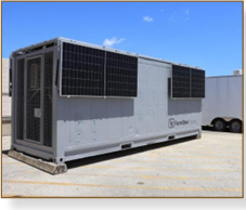
At the Comunidad de Regantes del Canal Alto de Villares, this transition is underway. The irrigation community manages approximately 2,500 hectares of farmland and recently completed a major infrastructure modernisation programme. To build on this investment, an integrated monitoring and decision-support system has been implemented, combining soil moisture monitoring, meteorological data, satellite imagery and water quality tracking. All data is consolidated into a unified platform to support real-time irrigation decisions.
This approach provides deeper understanding of water use in the field. Irrigation can be adjusted based on actual soil conditions, anticipated weather patterns and crop development. Satellite imagery, updated every five days, enables continuous monitoring of vegetation status, helping identify areas of under- or over-irrigation. Soil moisture sensors provide detailed insight into water distribution at different depths, allowing irrigation performance to be assessed and improved. Environmental monitoring systems track nutrient leaching and help understand the impact of irrigation practices on surrounding water bodies.
Early indications highlight significant potential benefits: water savings of up to 25%, reduced energy consumption for pumping, and improved crop performance. As climate variability increases and water resources become more constrained, the role of data in irrigation will continue to grow. Projects such as Alto Villares demonstrate how combining monitoring technologies, satellite intelligence and decision-support systems can support a more efficient, sustainable and resilient model of irrigation management.