
Context Capture Optimizes Data Processing and Integration, Delivering a Digital Twin to Plan New Infrastructure and Safeguard Citizens
A Milestone Eruption in the Canary Islands
After 50 years of dormancy, the volcano that forms the Cumbre Vieja Ridge on the island of La Palma in the Spanish Canary Islands erupted in September 2021, resulting in one of the archipelago’s most destructive volcanic events in 500 years. Lasting 85 days, it is estimated to have caused up to EUR 843 million in damage to the island’s infrastructure. Spewing lava as high as 500 meters and with a flow traversing the island, the volcano destroyed buildings, towns, and approximately 350 hectares of banana plantations. It also destroyed more than 2,500 homes, forcing 7,000 residents to evacuate. While no deaths resulted from the eruption, the challenges at hand include rebuilding the communities and determining how best to protect the thousands of people who live on the slopes of the ridge from future catastrophic events.
Responsible for producing the official cartography of Spain and managing, maintaining, and communicating geographic and spatial data, the National Geographic Institute (CNIG) was tasked with ascertaining the current state of La Palma after the 2021 volcanic eruption. “The project involved obtaining a realistic landscape of the new orography of the island of La Palma following the changes caused by the last eruption of the Cumbre Vieja ridge between September 19 and December 13, 2021,” said Celia Sevilla, head of international projects at CNIG. While the initial project objective was a digital cartography model to help reconstruct the island, another objective was to develop the virtual model as a tool to help define protection and management plans aimed at safeguarding communities and infrastructure, which will help increase the island’s resiliency to natural disasters.
Integrating Multisourced Data and Models
To obtain an accurate digital representation of the new orography of La Palma, CNIG had to merge two models. The first model was obtained from existing aerial photographs of the island with a ground sample distance of 25 centimeters, while the second model was created from 14,000 drone-captured images with a high-resolution ground pixel size of 5 centimeters that focused on the affected area, including craters and lava flow. Integrating the two different types of data with very different geometric resolutions presented challenges, compounded by the surface irregularity and disappearance of identifiable points on the ground due to the lava. “The biggest challenge was integrating very disparate resolutions, as well as searching and locating identifiable points for georeferencing, because the lava flows had caused much of the land in the area to disappear,” said Sevilla.
In addition to the lava-affected topography and data integration issues, CNIG also faced time constraints. They needed to generate an accurate reality model and digital twin in a short period of time. From the digital twin, they also had to create updated digital elevation models to correct the official cartography published by the Spanish National Geographic Institute, accessible both digitally via CNIG’s download center, map viewers, and mobile applications, and as printed versions. To quickly integrate the large survey data and models with varying resolutions into a realistic, multipurpose digital landscape, CNIG required comprehensive and flexible reality modeling technology.
Leveraging ContextCapture for Landscape Modeling
Based on prior experiences with other projects, CNIG selected ContextCapture to integrate the aerial photos covering the entire island pre-eruption with the drone images captured during the period that the volcano remained active. This process would allow them to digitally reconstruct the new island landscape. Using Bentley’s reality modeling application allowed the different resolutions to be integrated into a single landscape. “ContextCapture has perfectly resolved the development of models from a large number of photographs while allowing the integration of different data sources, along with different resolutions,” said Sevilla.
The software’s flexibility, interoperability, and advanced processing capabilities enabled CNIG to quickly merge the 14,000 high-resolution, drone-captured images with the lower resolution photographs into an accurate single-landscape digital twin model to virtually study the area and plan new infrastructure development.
Digital Twin Drives Virtual Planning and Reconstruction
Using ContextCapture provided a quick, simple, and cost-effective solution that met CNIG’s landscape reconstruction objectives, as well as their ongoing cartographic requirements. The creation of a digital twin offers a multipurpose solution, making information easily accessible to agencies and the public for various applications. Easy digital reconstruction of the territory now makes it possible for the government to keep citizens regularly informed.
“The fact that a reality model of the new appearance of the island of La Palma is available is the fastest, closest, and most accurate way of showing it to citizens,” said Sevilla. The Bentley-based digital solution reduces the environmental impact of manual on-site methods while saving time and costs, as well as providing citizens with a glimpse into the current state of their plots and homes in a safe and agile manner.
Digitization of the project enabled virtual access to the study area, which is not physically permitted due to safety and environmental protection issues. The model facilitates virtual reconstruction and planning to rebuild infrastructure and respond to events similar to the Cumbre Vieja eruption. It enables the implementation of proactive protection and management plans to safeguard people and property from future natural disasters. “The speed in obtaining the data, the simplicity of its processing, and its subsequent integration into the existing model make this methodology an option for any future episodes,” said Sevilla.
Project Summary
Organization: The National Geographic Institute (CNIG)
Solution: Survey and Monitoring
Location: La Palma, Santa Cruz de Tenerife, Spain
Project Objectives:
- To create a digital twin of the island to help plan reconstruction and infrastructure redevelopment.
- To promote digitization for defining disaster protection and management plans, increasing resilience.
Project Playbook: ContextCapture, MicroStation
Fast Facts
- In 2021, Cumbre Vieja erupted on La Palma, resulting in the island’s largest volcanic eruption on record.
- CNIG was tasked with obtaining a digital realistic landscape of the island following changes caused by the volcano.
- CNIG used ContextCapture to integrate 14,000 drone-captured images with low-resolution photographs into a single, accurate digital twin.
ROI
- Using Bentley’s reality modeling application saved time and costs while reducing the environmental impact.
Callout Quote: “ContextCapture allows different resolutions to be integrated into a single landscape.” – Celia Sevilla, Head of International Projects, Spanish National Center for Geographic Information
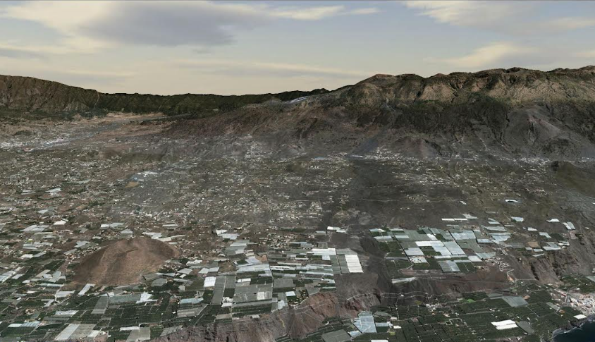
Image 1: CNIG was tasked with obtaining a digital realistic landscape of the island following changes caused by the Cumbre Vieja volcano on La Palma. Image courtesy of Spanish National Center for Geographic Information.
Image 2: CNIG used ContextCapture to integrate 14,000 drone-captured images with low-resolution photographs into a single, accurate digital twin. Image courtesy of Spanish National Center for Geographic Information. The digital twin enabled CNIG to virtually study the area, plan new infrastructure development, and define protection and management plans to safeguard people in the area from future eruptions. Image courtesy of Spanish National Center for Geographic Information.